

Weather and climate conditions this week in Wisconsin
Here are this week’s take-home points about the weather. As a reminder, AgWOW reports will be published weekly throughout the growing season. Scroll down for the full report.
Additionally, we’re collecting user feedback. Regardless of whether it’s your first time here or if you are a regular user, we’d love to hear from you!
Key Points
Recent Conditions
- For another week, temperatures remained well above normal across the state. Most of the state was at least 9°F above normal, with 6-9°F in the north.
- Rainfall totals across western, central, and northern Wisconsin were commonly at or above 0.5”. Totals were highest in the far northwest (2-3”), with the lowest totals in the east-central and southeast regions.
Impact
- For Wisconet stations included in the chart and table, northwest and west-central stations saw the largest increases in soil moisture, while stations in the south and east saw decreases.
- Satellite-based soil moisture estimates indicate that dryness improved in parts of the northwest following last week’s rainfall (1-3”).
- Drought improved in northwestern counties following above-normal rainfall last week. D2-D4 coverage dropped by 5%, and D3-D4 coverage dropped by over 7%.
- Soybean harvest is very near to completion, with corn harvest running ahead of the average pace. Winter wheat is off to a strong start with 75% of the crop rated at good to excellent condition.
Outlook
- Rain chances are low over the next 7 days, with the best chances for rain in the northeast region on Thursday (11/5).
- Mid-November temperatures are very likely to be above normal (70-90% odds). Precipitation is leaning slightly towards below normal for nearly all of Wisconsin.
- November temperatures will likely be above normal statewide (50-70% odds), with precipitation leaning above normal in the west.
- Temperatures will likely be above normal statewide into the first part of winter (Nov-Jan). Precipitation is uncertain for most of the state with “equal chances.”
Agronomic, Fruit, and Vegetable Considerations
Field Conditions
- Rain this week has delayed harvest operations. Keep equipment off wet soils to reduce compaction and prevent rutting.
- Crop conditions are highly reflective of moisture throughout the state. Late season moisture is causing some issues with grain quality, especially in soybean. Prioritize any remaining affected fields to ensure a timely harvest.
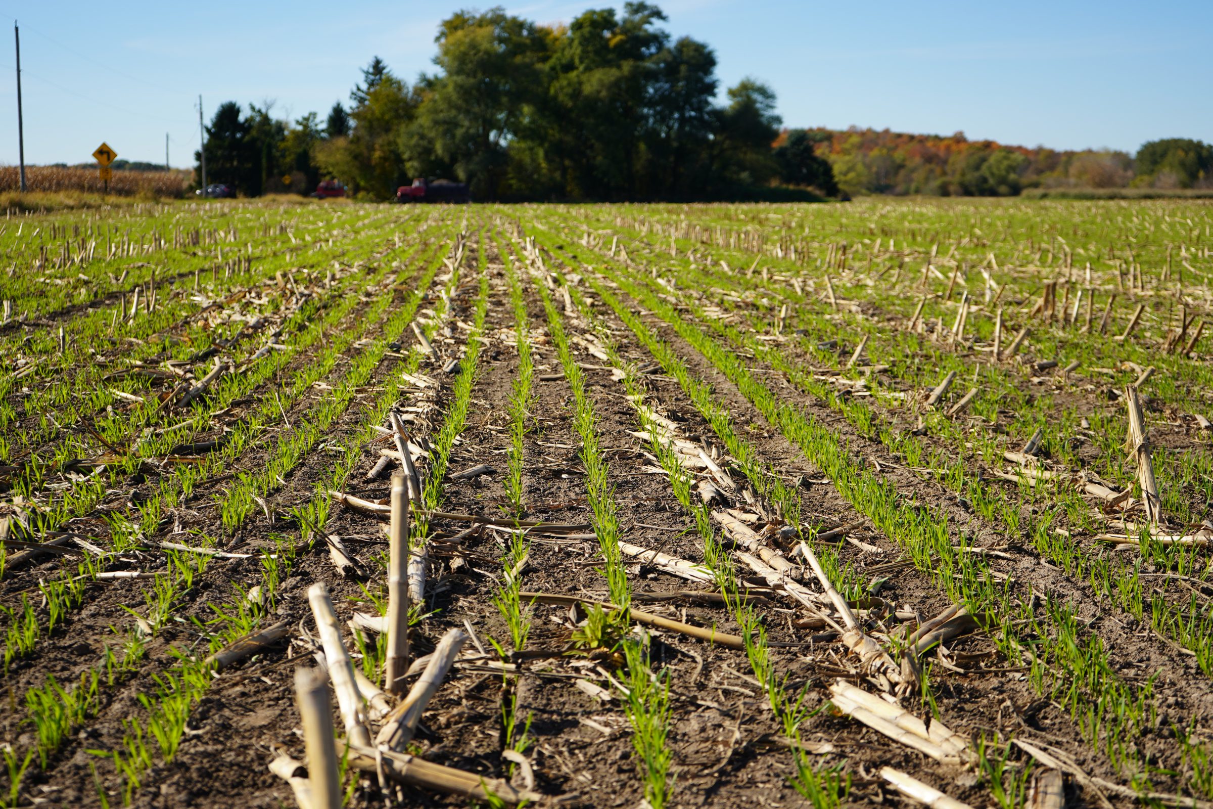
- Many cover crops are planted for the year, but there is still a window after grain harvest for overwintering species such as rye, triticale, and camelina.
- After harvest is a great time to take soil samples. Make plans to stay up to date with your nutrient management plan. Use a Certified Soil Lab.
Forage Management
- Read about the impacts of drought on alfalfa if your crop was affected this year and how to manage next year.
- Silo gas has been present again this year in various structures, potentially due to higher nitrate content in silage. Use caution when working with or near these storage structures.
- After corn is harvested, you may consider grazing corn stalks or harvesting corn stover, based on livestock needs.
Pest Management
- Scout fields to note what weed species are part of a late season flush. Pay special attention to winter annual species.
- Planting cover crops after grain harvest is a great way to reduce soil erosion and provide weed control.
- Reducing next year’s weed seed population can be accomplished with combine cleaning.
Manure Applications
- Reminder of Wisconsin’s NR 151 Runoff Rules with the timing of manure spreading and current runoff levels. Check DATCP Runoff Risk Advisory Forecast.
- As you conduct fall spreading, keeping field records is important to estimate crop nutrient needs. Refer to A2809 for guidance. Fall is also a great time to have manure samples analyzed for nutrient content.
Small Grains
- Read the Top 9 Recommendations for Winter Wheat Establishment in 2026. Check emerged stands for uniformity.
Fruit Considerations – General
- Fall Sanitation: Clean up weeds around trees and vines, mow aisles to allow for better light penetration to aid in decomposition of leaf/plant material.
- Fall Sanitation: After leaf drop, chop, compost, remove or burn (where permitted) fallen leaf and plant material to limit potential for disease inoculum and any overwintering pests.
- Remember to note observable fruit damage at harvest to make adjustments in next year’s pest management plan.
- Wisconsin fruit growers can reference the Midwest Fruit Pest Management Guide for a list of registered products and recommended best practices. View the MFPMG Online.
- Reminder: Always read and follow directions on the label and keep in mind pre-harvest intervals (PHI) as we move through harvest!
Vegetable Considerations – General
- As warm conditions have continued into November, monitor perennial crops for any late growth that may be susceptible to disease. Any rotted or diseased tissue should be removed and destroyed.
- As fall weather gets colder you can still plant a cold tolerant cover crop such as cereal rye. Be sure to have a plan for terminating your cover crop before you plant. Consider your goals for your cover crop, and plan accordingly for the right amount of biomass to meet those goals.
- Consider how you can prepare for a strong El Niño this winter. This article from University of Minnesota Extension has tips including increased pest monitoring and planning for potential warm and wet spring conditions.
Vegetable Considerations – Disease
- Continue to monitor for post-harvest storage issues on vegetables which could include soft rots and gray mold. Optimal storage conditions vary by crop, so be sure to know the right conditions for every crop.
Vegetable Considerations – Insects
- Pest management for next year’s crops starts this fall as many insects and diseases overwinter on crop residue. Residue management (either removing or tilling in residue) can help reduce next year’s pest and disease pressure. Pests include asparagus beetles, crucifer flea beetles, imported cabbage worms, squash bugs, onion maggots, and more.
Dive deeper into each report section by clicking a topic below.
Precipitation Trends
7 Day Precipitation
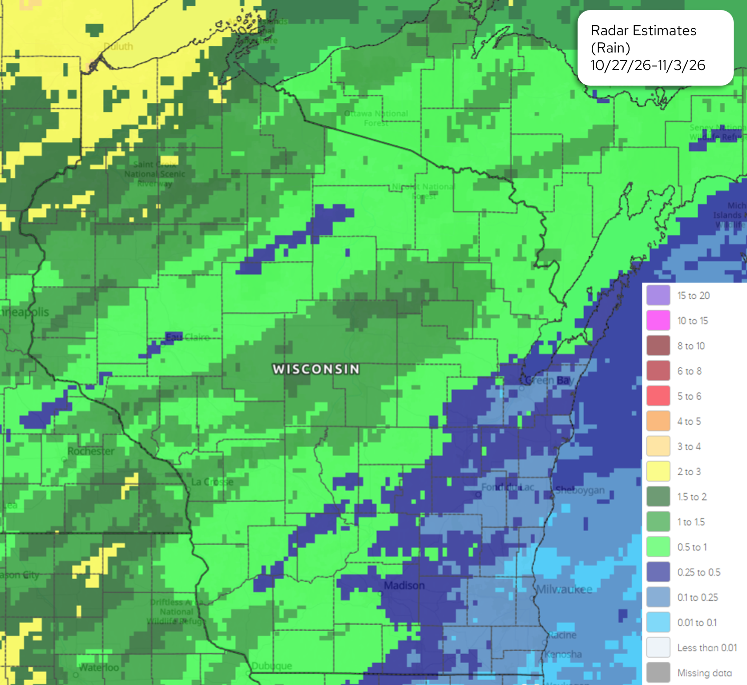
Image Description ↓
Map titled “Radar Estimates (Rain) 10/27/26–11/3/26” displaying 7-day total precipitation estimates across Wisconsin. Southeastern and eastern Wisconsin along Lake Michigan (including Green Bay, Milwaukee, and Madison) received between 0.25 to 0.5 inches of rain (blue shades) with localized areas up to 0.5 to 1.0 inch. Central and western regions of Wisconsin received 0.5 to 1.5 inches (light green to green shades). A key on the right defines rainfall amounts in inches ranging from less than 0.01 up to 15 to 20 inches.
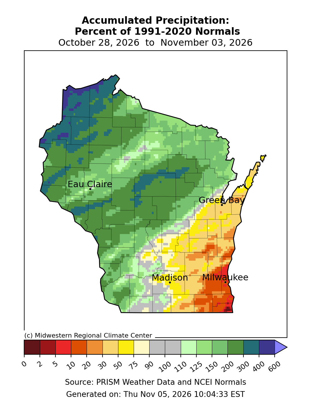
Image Description ↓
Precipitation percentage map generated by the Midwestern Regional Climate Center showing accumulated precipitation as a percent of 1991–2020 normals from October 28, 2026 to November 3, 2026. Green and dark green shades dominate northern, western, and central Wisconsin, corresponding to values from 110% up to 400% of normal. Southeastern Wisconsin, including areas near Madison and Milwaukee, is shaded in yellow, orange, and red, representing below-normal precipitation levels between 2% and 75% of normal. The bottom scale spans values from 0 to 600 percent based on PRISM Weather Data and NCEI Normals.
- Rainfall totals across western, central, and northern Wisconsin were commonly at or above 0.5”. Totals were highest in the far northwest (2-3”, or 200-400% of normal).
- East central and southeastern counties were the driest, with totals of 0.25” or less.
- Highest Wisconet station total from last week: 1.51” (Grantsburg, Burnett County). Totals in Burnett County were as high as 300-600% of normal.
30 Day Precipitation
- Nearly all of Wisconsin received below-normal precipitation over the past 30 days. Southern counties were the driest, with totals commonly less than 1.5” (≤50% of normal).
- Far northwest counties were the wettest, with totals that were near to normal (2-4”). Most of this rain fell within the past 7 days.
90 Day Precipitation
- In the southern 2/3 of the state, totals ranged from 7.5-15” for most. Rainfall totals in this region were near to above average (90-150%+).
- Far northern counties were the driest (5” or less), with most locations receiving totals that were at or below 75% of normal. Along the MI border, totals were ≤50% of normal.
2026 Precipitation
- Southern and central counties – 2-8” above normal for the year, with pockets of 8-12” above normal.
- Far north and northwest counties – 4-12” below normal for the year.
Soil Moisture and Temperature Trends
Soil Moisture Models
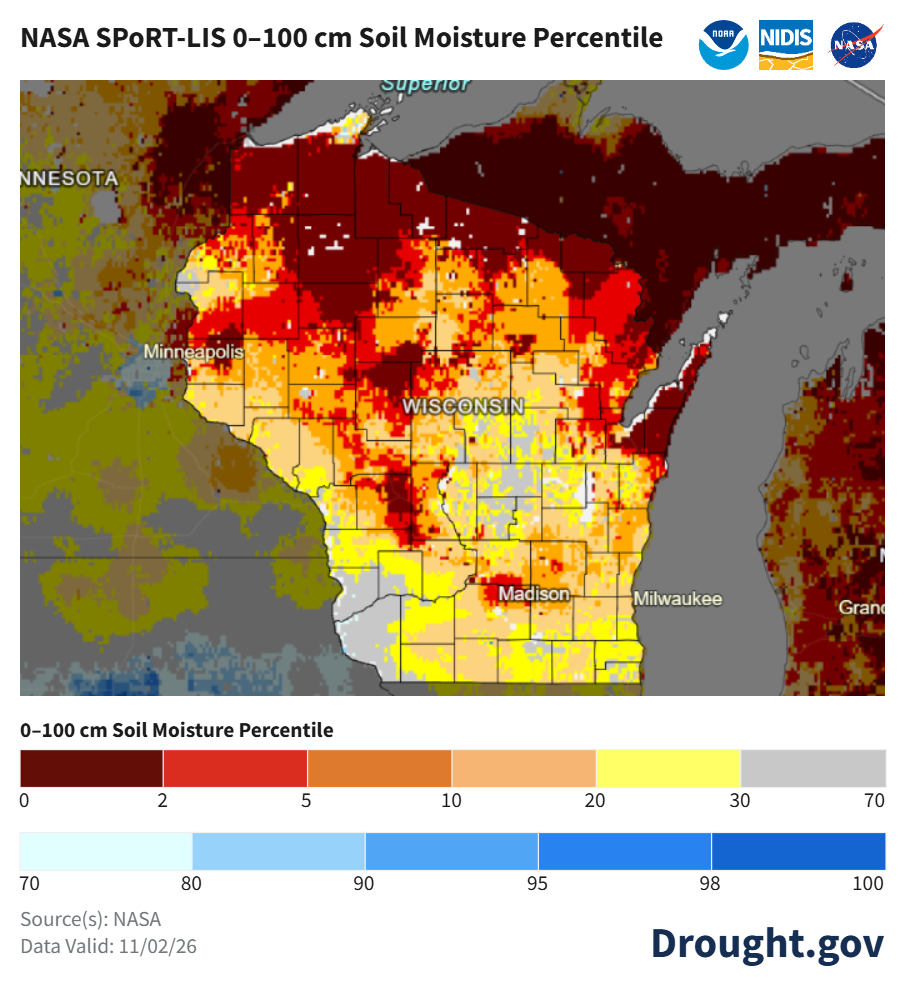
Image Description ↓
Map titled “NASA SPoRT-LIS 0–100 cm Soil Moisture Percentile” published by Drought.gov, NOAA, NIDIS, and NASA, with data valid as of November 02, 2026. The map depicts soil moisture conditions across Wisconsin. Northern and north-central Wisconsin remain severely dry with percentiles predominantly in the 0 to 5 range (dark red and red). Central and southwestern Wisconsin feature broad areas in the 5 to 20 range (orange and light orange). South-central areas around Madison show yellow and gray shading indicating 20th to 70th percentiles. The legend spans 0 to 100 percentile values.
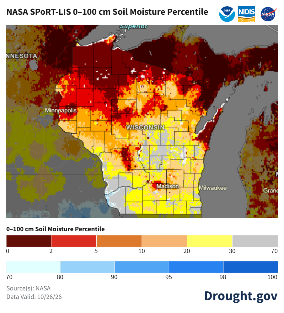
Image Description ↓
Map titled “NASA SPoRT-LIS 0–100 cm Soil Moisture Percentile” published by Drought.gov, NOAA, NIDIS, and NASA, showing data valid for October 26, 2026. Large portions of northern, central, and northwestern Wisconsin are shaded dark red and bright red, corresponding to the 0 to 5th soil moisture percentiles (indicating dry conditions). Southern Wisconsin near Madison and Milwaukee shows mixed conditions ranging from 10th to 30th percentiles (orange and yellow shades). Small areas in far southern Wisconsin show percentiles in the gray category (30 to 70th percentile). The bottom color scale maps percentiles from 0 to 100.
- Satellite-based soil moisture estimates indicate that soil moisture percentiles did not change greatly from last week’s report.
- Notes on how to interpret the maps:
- Red areas = top 5 driest in 100 years.
- Dark red areas = top 2 driest in 100 years.
- Dark blue areas = top 2 wettest in 100 years.
Wisconet Soil Moisture
- For Wisconet stations included in the chart and table, plant available water increased after 0.5”-1.5” of rain fell at most stations.
- Northwest and west-central stations saw the largest increases, while stations in the south and east saw decreased soil moisture.
- Stations included in the chart and table that are currently in D1 drought are Suring (Oconto), Marshfield (Marathon), Osseo (Trempealeau), River Falls (Pierce) and Rice Lake (Barron).
- The table (below) shows total precipitation and changes in plant available water from October 26th (Start) to November 2nd (End).
- What is plant available water? To learn more, read this article from UW Extension Ag Water Quality on plant available water. There is also a webinar from UW Extension on soil water management that you can watch.
- Example: Imagine that you have 4 inches of soil in the bottom of a bucket. In that soil, there are 1.5 inches of plant available water. Therefore, if you removed the soil and left only the water available for plant roots to take up, you would have 1.5 inches of water in the bottom of the bucket.
- The wilting point is when plant available water is at 0 inches, and the plant can no longer access water at that depth in the soil.
| Wisconet Station | County | Total Precipitation (in.) | 4″ Start | 4″ End | 8″ Start | 8″ End | 20″ Start | 20″ End |
|---|---|---|---|---|---|---|---|---|
| Arlington | Columbia | 0.00 | 0.79 | 0.83 | 1.58 | 1.61 | 3.89 | 3.93 |
| Brillion | Calumet | 0.05 | 0.59 | 0.47 | 1.34 | 1.16 | 3.88 | 3.66 |
| Hancock | Waushara | 0.86 | 0.00 | 0.01 | 0.05 | 0.06 | 0.13 | 0.08 |
| Lancaster | Grant | 0.81 | 0.78 | 0.90 | 1.71 | 1.86 | 4.81 | 4.96 |
| Marshfield | Marathon | 1.31 | 0.77 | 0.91 | 1.89 | 2.03 | 4.96 | 5.06 |
| Osseo | Trempealeau | 0.98 | 0.50 | 0.86 | 1.09 | 1.65 | 3.63 | 4.17 |
| Porter | Rock | 0.42 | 0.86 | 0.73 | 1.86 | 1.73 | 4.74 | 4.56 |
| Rice Lake | Barron | 1.51 | 0.19 | 0.55 | 0.53 | 1.16 | 1.20 | 1.87 |
| River Falls | Pierce | 1.48 | 0.28 | 0.49 | 0.87 | 1.27 | 0.87 | 1.27 |
| Suring | Oconto | 0.87 | 0.30 | 0.45 | 0.51 | 0.70 | 0.51 | 0.70 |
| Walworth | Walworth | 0.08 | 0.84 | 0.75 | 1.80 | 1.66 | 4.82 | 4.68 |
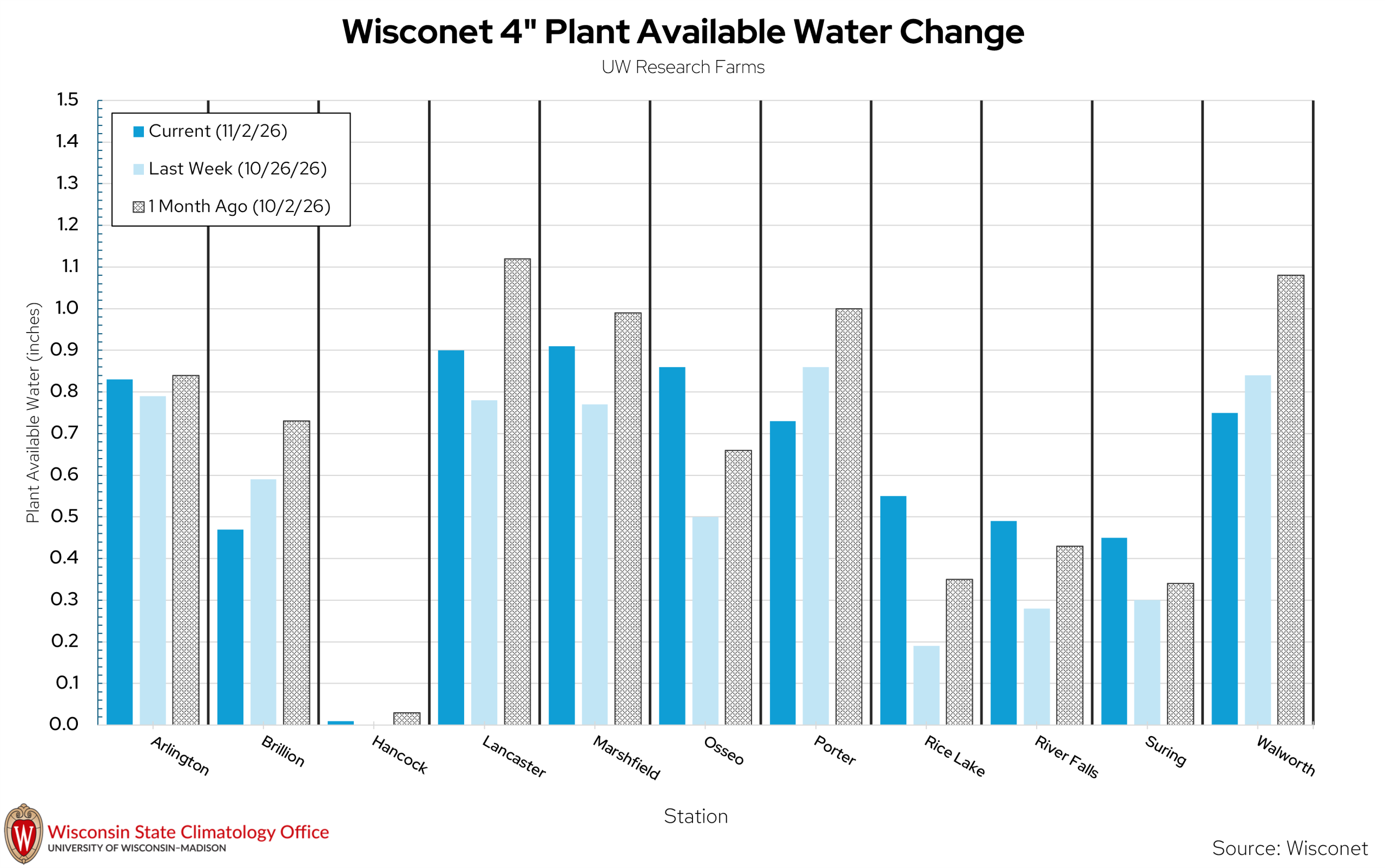
| Wisconet Station | Current 4″ Soil Moisture | Last Week’s 4″ Soil Moisture | 1 Month Ago 4″ Soil Moisture |
|---|---|---|---|
| Arlington | 0.83 | 0.79 | 0.84 |
| Brillion | 0.47 | 0.59 | 0.73 |
| Hancock | 0.01 | 0.00 | 0.03 |
| Lancaster | 0.90 | 0.78 | 1.12 |
| Marshfield | 0.91 | 0.77 | 0.99 |
| Osseo | 0.86 | 0.50 | 0.66 |
| Porter | 0.73 | 0.86 | 1.00 |
| Rice Lake | 0.55 | 0.19 | 0.35 |
| River Falls | 0.49 | 0.28 | 0.43 |
| Suring | 0.45 | 0.30 | 0.34 |
| Walworth | 0.75 | 0.84 | 1.08 |
USDA Soil Moisture Reports
- 70% and 68% of agricultural soils in the state are reported as having adequate topsoil and subsoil moisture, respectively. The subsoil value increased by 1%.
- 25% and 29% of agricultural soils in the state are reported as having short to very short topsoil and subsoil moisture, respectively. The topsoil value increased by 1%.
Wisconet Soil Temperature
- At 4” depth – temperatures range from the low to middle 50s.
- At 8” depth – temperatures range from the low to upper 50s.
- At 20” depth – temperatures range from the low to upper 50s.
U.S. Drought Monitor
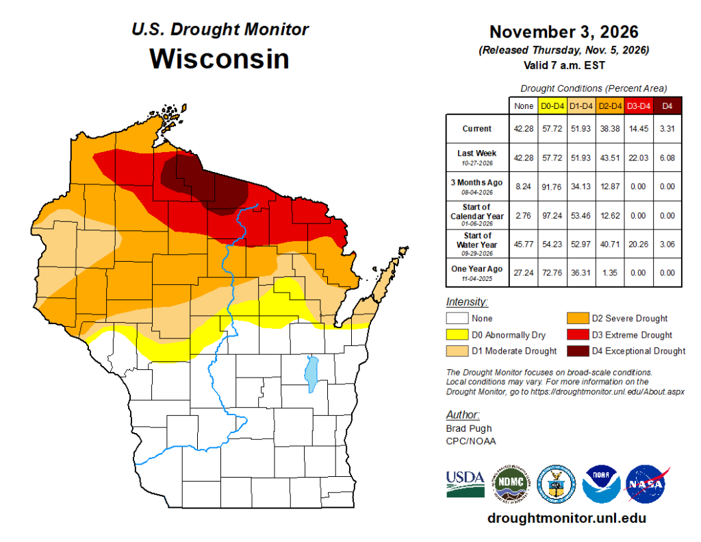
Image Description ↓
Map titled U.S. Drought Monitor Wisconsin released November 5, 2026, valid November 3, 2026. The map illustrates drought severity across the state using color categories: white for none in southern counties, yellow for abnormally dry (D0), tan for moderate drought (D1), orange for severe drought (D2) across central region, bright red for extreme drought (D3) in northern counties, and dark brown for exceptional drought (D4) near the northern border. An accompanying table lists percentage area statistics: Current values show 42.28% none, 57.72% D0-D4, 51.93% D1-D4, 38.38% D2-D4, 14.45% D3-D4, and 3.31% D4. Historical comparison rows are included for Last Week, 3 Months Ago, Start of Calendar Year, Start of Water Year, and One Year Ago. Author credited is Brad Pugh, CPC/NOAA.
Compared to last week:
- Midwest: D1-D4 coverage decreased by 1-2%. A large portion of Minnesota and northwestern Wisconsin experienced 1 class improvement. 1 class degradations were common across the south.
- 68.8% of the Midwest region is drought free (~31.2% in D1-D4).
- Wisconsin: Drought improved in northwestern counties. D2-D4 coverage dropped by 5%, and D3-D4 coverage dropped by over 7%.
U.S. Drought Monitor Time Series
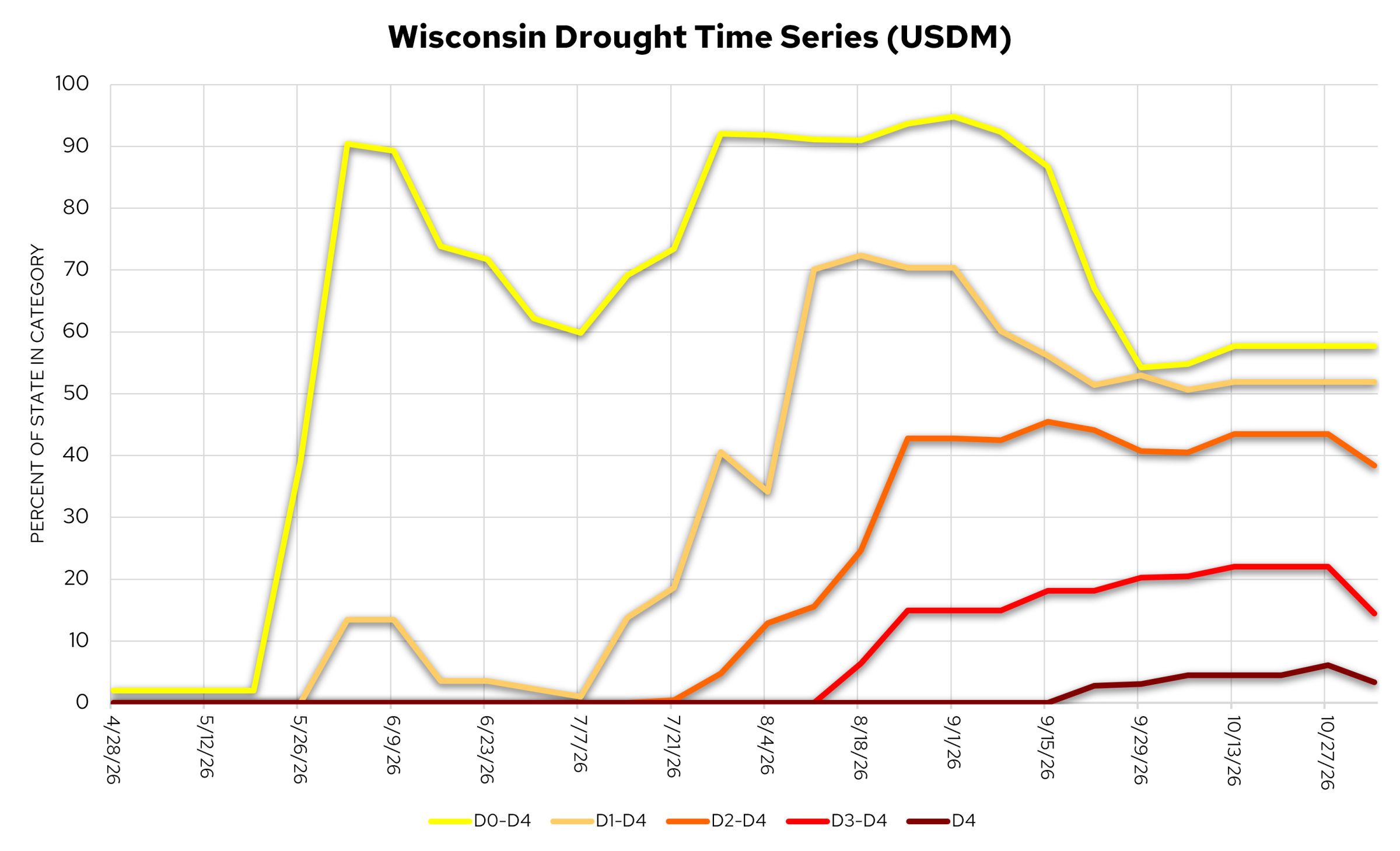
Image Description ↓
Line graph titled Wisconsin Drought Time Series (USDM) plotting percent of state area in drought category on the vertical axis against dates from 4/28/26 to 10/27/26 on the horizontal axis. Five colored trend lines track categories: D0–D4 (yellow) rises sharply in late May to near 90%, peaking around 95% in early September before tapering to ~58%; D1–D4 (tan) peaks near 72% in August; D2–D4 (orange) increases through summer to peak around 45% in September; D3–D4 (red) rises starting in August to stabilize around 22%; and D4 (dark brown) appears in mid-September, hovering around 3% to 6%.
- D0 coverage = 57.7%; D1 coverage = 51.9%; D2 coverage = 38.4%; D3 coverage = 14.5%; D4 coverage = 3.3%
Temperature Trends
7 Day Temperatures
- Average temperatures were in the low-to-mid 50s in the southern and central regions. Further north, temps were in the upper 40s.
- Temperatures were well above normal across the state last week. Most of the state was at least 9°F above normal, with 6-9°F in the north.
30 Day Temperatures
- Average temperatures were in the upper 50s in the southern half of Wisconsin. Across the north, temperatures were in the low 50s.
- Temperatures were 6-10°F above normal across most of Wisconsin.
Growing Degree Days (Base 50°F)
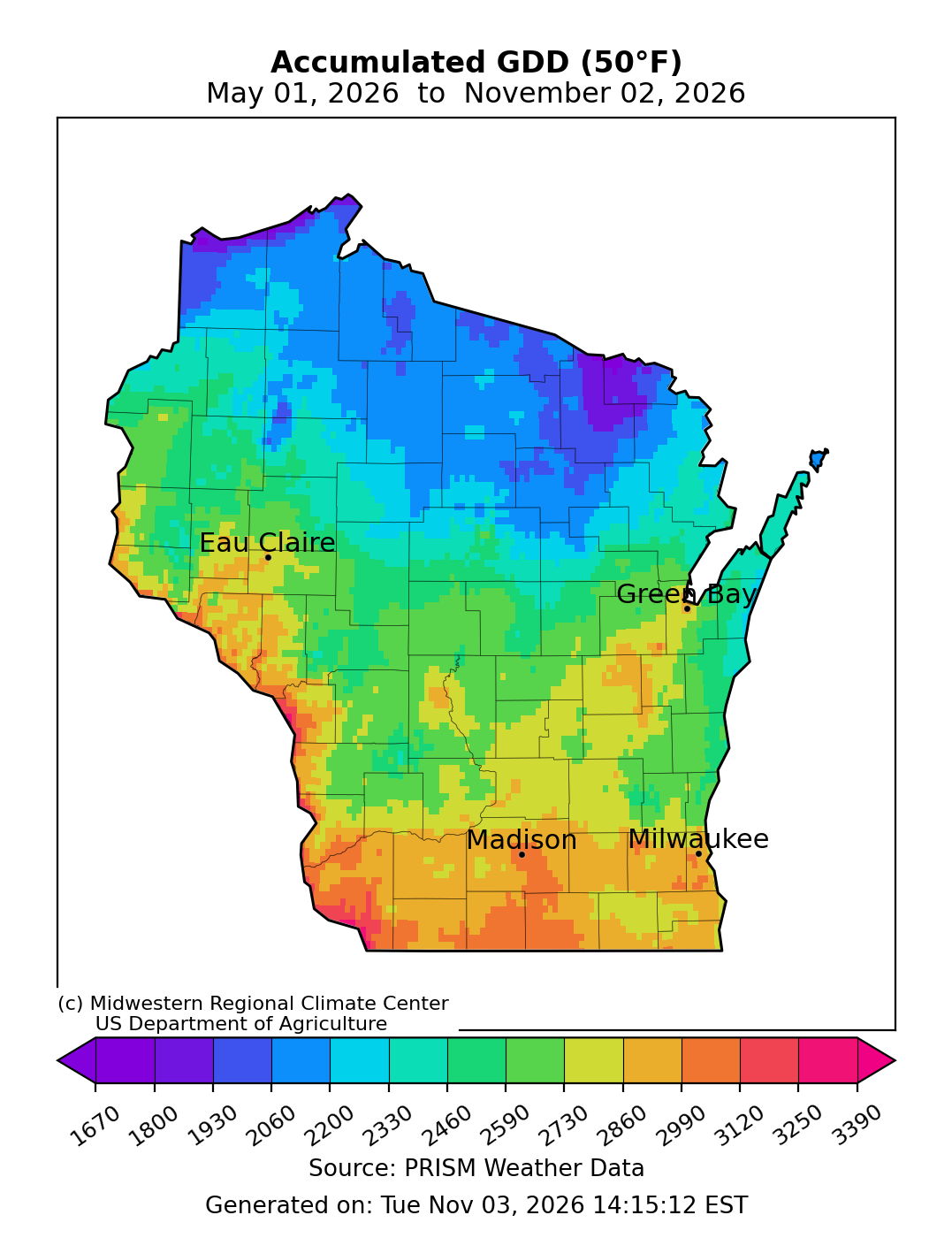
Image Description ↓
Map titled “Accumulated GDD (50°F) May 01, 2026 to November 02, 2026” produced by Midwestern Regional Climate Center and US Department of Agriculture using PRISM Weather Data, generated November 03, 2026. The map displays a gradient of accumulated Growing Degree Days across Wisconsin, ranging from under 1,670 GDD in the far north (shaded purple/blue) to over 3,120 GDD in southern counties near Madison and Milwaukee (shaded orange/red). Central areas including Eau Claire and Green Bay show mid-range values between 2,200 and 2,730 GDD. A color bar scale at the bottom maps GDD values from 1,670 to 3,390.
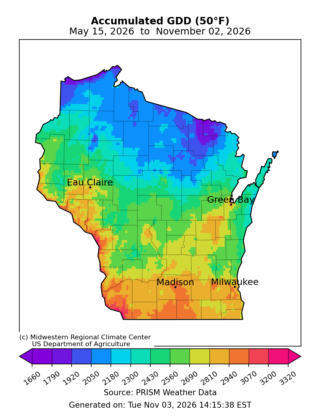
Image Description ↓
Map titled “Accumulated GDD (50°F) May 15, 2026 to November 02, 2026” produced by Midwestern Regional Climate Center and US Department of Agriculture using PRISM Weather Data, generated November 03, 2026. The map shows accumulated GDD values across Wisconsin starting from May 15. Values range from under 1,660 GDD in northern regions (purple/blue shades) to around 2,940 to 3,070 GDD along the southern border near Madison and Milwaukee (orange/red shades). Central regions around Eau Claire and Green Bay range between 2,180 and 2,560 GDD. A color legend at the bottom spans GDD values from 1,660 to 3,320.
- Starting May 1 – Growing degree day accumulation ranges from 3250 GDD in the far south and west to 2060 GDD in the far north. These values are 110-120% of normal.
- Starting May 15 – Growing degree day accumulation ranges from 3200 GDD in the far south and west to 2050 GDD in the far north. These values are 115-120% of normal.
Crop Progress and Condition
NASS Progress Report – November 1, 2026
- Wisconsin had 5.9 days suitable for fieldwork statewide. Where fields were dry, fall tillage and manure applications were being completed.
- Soybeans were 94% harvested compared to the average of 84%.
- Corn is 61% harvested, 4% ahead of the 5-year average pace.
- Corn conditions are 60% good to excellent, unchanged from last week’s report.
- Winter wheat is 95% planted and 74% emerged. The crop is rated at 75% good to excellent.
- Read the full USDA report.
Forecasts and Outlooks
7 Day Precipitation Forecast
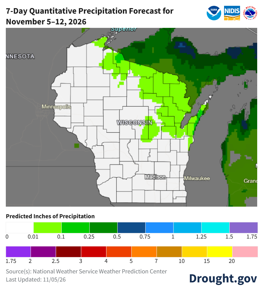
Image Description ↓
Map produced by Drought.gov titled 7-Day Quantitative Precipitation Forecast for November 5–12, 2026. Most of southern and central Wisconsin shows white, indicating zero predicted inches of precipitation. Bright green shading covers northern and eastern portions of the state, indicating predicted rainfall between 0.01 and 0.25 inches. Darker green shades representing higher predicted precipitation cover areas further north outside Wisconsin toward Lake Superior. The bottom scale ranges from 0 to 20 inches, and source notes credit the National Weather Service Weather Prediction Center, updated November 5, 2026.
- When? – The best chances for light rain are on Thursday (11/5), with a quiet stretch of weather to follow.
- Where? – Rain chances are low over the next 7 days, with the best chances for rain in the northeast region.
- Check your local forecast for details on totals and timing.
- Average precip (1991-2020) for this week: 0.49”.
7 Day Frost/Freeze Outlook
- Over the next 7 days, overnight lows of 32°F or colder could be widespread on Friday morning (11/6) and Saturday morning (11/7).
- Some locations along the Mississippi River have not yet experienced an overnight low of 32°F or colder.
- To get the latest 7-day frost and freeze guidance, check out the NWS Frost Freeze Decision Support Services Page.
8-14 Day Temperature and Precipitation Outlook
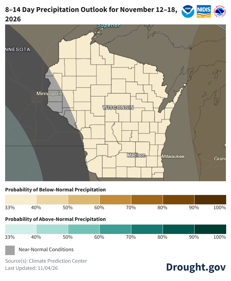
Image Description ↓
Climate map from Drought.gov titled 8–14 Day Precipitation Outlook for November 12–18, 2026. The state of Wisconsin is completely shaded in light beige, indicating near-normal precipitation conditions statewide. The map scale provides color codes for Probability of Below-Normal Precipitation, Probability of Above-Normal Precipitation, and Near-Normal Conditions shaded in gray. Source credit is given to the Climate Prediction Center, updated November 4, 2026.
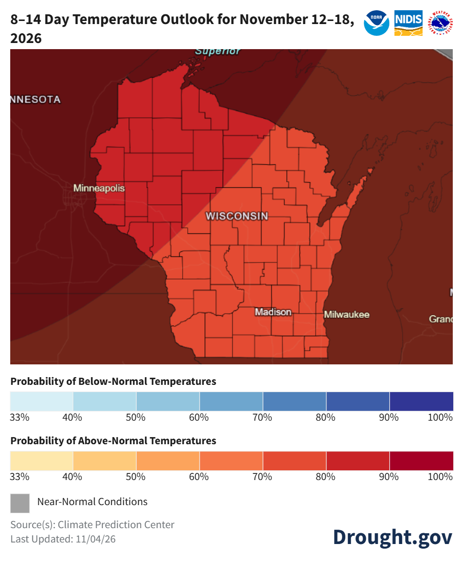
Image Description ↓
Climate map from Drought.gov titled 8–14 Day Temperature Outlook for November 12–18, 2026. The entire state of Wisconsin is shaded in shades of orange and red, denoting high probabilities of above-normal temperatures. A diagonal region across northwestern Wisconsin shows a darker red shade corresponding to a higher probability tier. Color keys below the map illustrate probability scales for below-normal and above-normal temperatures ranging from 33% to 100%. Source credit is given to the Climate Prediction Center, updated November 4, 2026.
- Mid November: Temperatures are very likely to be above normal (70-90% odds, highest in the north and west). Precipitation is leaning slightly towards below normal for nearly all of Wisconsin (33-40% odds).
- Statewide normals (1991-2020) for November 12-18 are 33.6°F and 0.46”.
30 Day Temperature and Precipitation Outlook
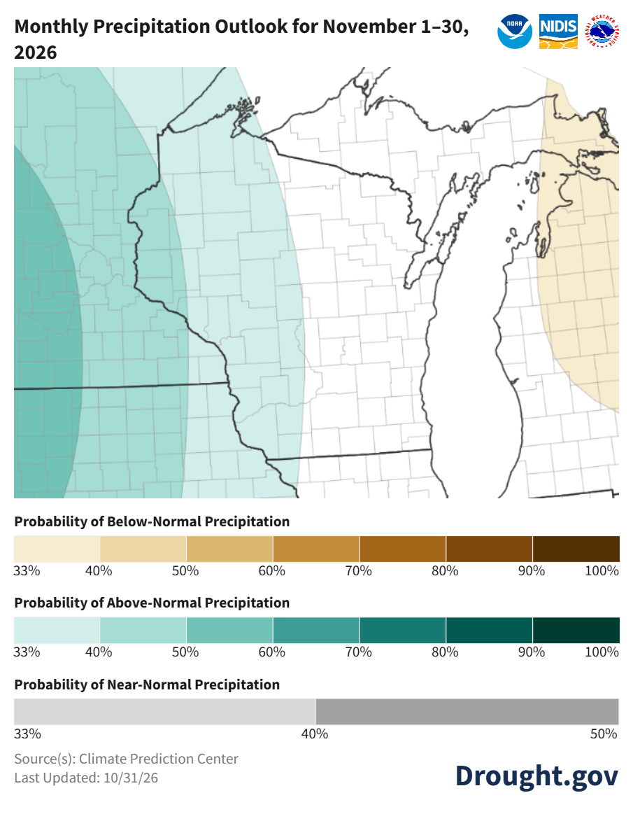
Image Description ↓
Map titled “Monthly Precipitation Outlook for November 1–30, 2026” published by Drought.gov, NOAA, NIDIS, and the National Weather Service, last updated October 31, 2026. The map highlights Wisconsin and surrounding regions. Western Wisconsin falls into a shaded green area indicating a 33% to 50% probability of above-normal precipitation, with probabilities decreasing towards the east. The legend defines probability ranges for below-normal (tan/brown shades), above-normal (light green to dark teal shades), and near-normal precipitation (gray shades). Source listed is Climate Prediction Center.
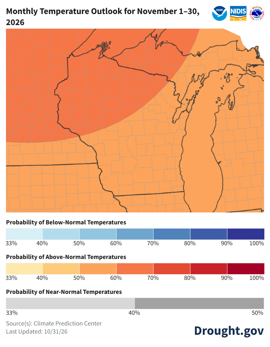
Image Description ↓
Map titled “Monthly Temperature Outlook for November 1–30, 2026” from Drought.gov, NOAA, NIDIS, and the National Weather Service, last updated October 31, 2026. The map covers Wisconsin and the surrounding Midwest region. Entire state of Wisconsin is shaded orange and dark orange, indicating a 50% to 70% probability of above-normal temperatures. Northwestern and western areas show higher probabilities (60%–70%) compared to southeastern areas (50%–60%). The legend provides color scales for below-normal (blue), above-normal (orange/red), and near-normal (gray) probabilities. Source listed is Climate Prediction Center.
- November: Temperatures will likely be above normal statewide (50-70% odds), with higher chances in the north (60-70%). Precipitation is leaning above normal in the west (33-50% odds), with uncertainty elsewhere.
- Statewide normals (1991-2020) for November 1-30 are 33.4°F and 1.99”.
90 Day Temperature and Precipitation Outlook
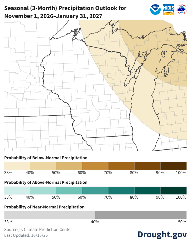
Image Description ↓
Map titled Seasonal (3-Month) Precipitation Outlook for November 1, 2026–January 31, 2027, published by Drought.gov and Climate Prediction Center. The entirety of Wisconsin is unshaded, indicating equal chances of above-, near-, or below-normal precipitation. Areas to the east over Lake Michigan and Michigan are shaded light tan (33% to 40% chance of below-normal precipitation).
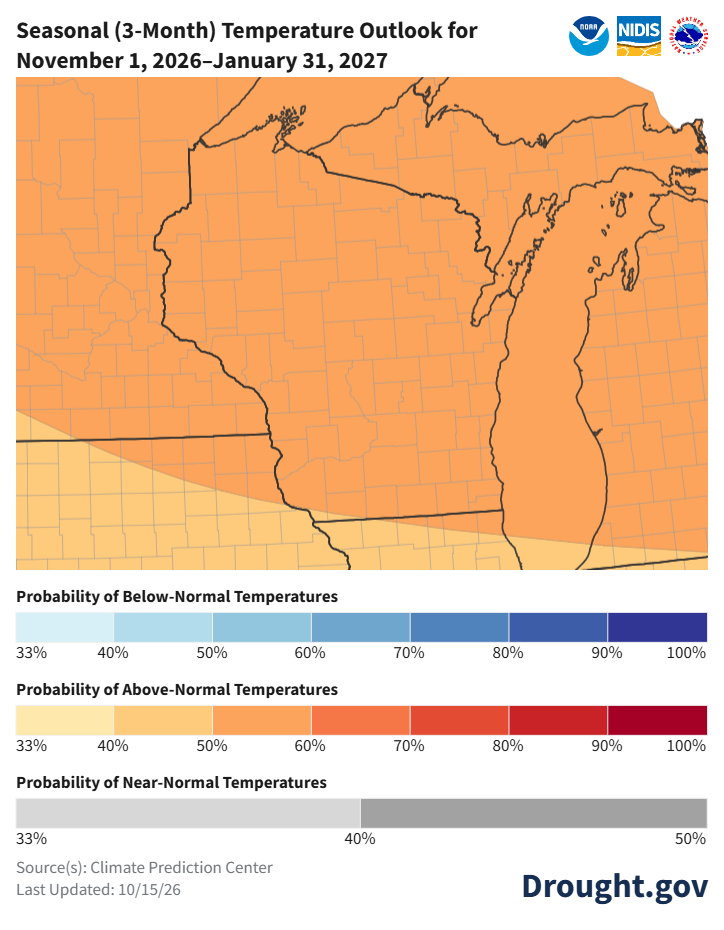
Image Description ↓
Map titled Seasonal (3-Month) Temperature Outlook for November 1, 2026–January 31, 2027, from Drought.gov. Wisconsin is covered in light orange and tan shading. Most of the state, including central and northern counties, indicates a 50% to 60% probability of above-normal temperatures, while far southern Wisconsin indicates a 40% to 50% probability of above-normal temperatures.
- Nov-Jan: Temperatures will likely be above normal statewide (50-60% odds), with precipitation uncertain with equal chances. In northeastern counties, there is a higher probability for below-normal precipitation (33-40% odds).
- Statewide normals (1991-2020) for Nov-Jan are 23.2°F and 4.72”.
User Survey
Are you a regular user of the Ag Weather Outlook for Wisconsin (AgWOW)? Or maybe you are viewing this page for the first time this week? Either way, we want to hear your feedback on this resource! Please take a few minutes and fill out this survey. Your feedback will help us better serve your ag-weather data needs through AgWOW.
If you have any trouble accessing or filling out the survey, please email Josh Bendorf at jbendorf@wisc.edu. Thank you!