This article is part 2 of a 2 part series explaining Karst and Silurian Bedrock
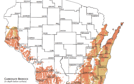
The terms karst topography and Silurian bedrock are related geological and hydrologic features. However, they can have different focuses and contexts. Karst pertains to unique landforms, such as sinkholes and rock outcropping, while Silurian refers to a specific area of shallow bedrock located in the eastern part of Wisconsin.
Water quality is an important issue to consider on landscapes with these features because having a thin soil layer means that precipitation water drains through the soil without much filtering. In these areas, fertile soils can look parched between rainfall events, even if the amount of rainfall is adequate. When water hits the fractured bedrock, it quickly moves to the groundwater aquifer. Groundwater contamination from sources such as septic systems, agricultural wastes, pesticides, and herbicides is a higher risk in karst areas because underground filtering is minimal.
State standards targeted to sensitive areas
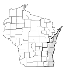
Consistent with Wisconsin state statutes, NR 151 is a rule that directs the Department of Natural Resources to use performance standards to meet runoff and water quality standards. NR 151 includes a performance standard to address spreading manure on soils in sensitive areas of the state (NR 151.075), where depth to bedrock is shallow and the bedrock is fractured (also described as karst topography or Silurian bedrock).
There are 1.6 million acres of cropland on Silurian bedrock. Of that, 17.6% or 283,795 acres, have less than 20 feet of topsoil that will be subject to restrictions under NR 151.075.
Valuable Tool = Nutrient Management Plan
A nutrient management plan is a very useful tool to use when farming in sensitive areas. Nutrient management planning can protect farm profitability, water quality (surface & groundwater), and soil erosion. The completed plan provides setbacks and considerations for nutrient application rates, timing and approved methods of fertilizing near water bodies, shows conduits to groundwater and where sensitive landscape features exist, as well as lists specific NR 151 standards that need to be met for each field.
In Wisconsin, farmers can develop a nutrient management plan using the free SnapPlus nutrient management planning software. The program alerts farmers when soil loss may cause nutrients to run off the field during or immediately after fertilizer or manure application. The nutrient management plan includes information to help surface and groundwater protection, such as meeting tolerable soil loss (T), maintaining a 5 foot setback from surface water, and preventing runoff from feedlots to enter into water bodies, to name a few.
Agricultural Best Management Practices to Follow
Verify the depth to bedrock on your land so you can manage for production and water quality.
Karst regions often have shallow soils with some being less than 36″ deep. A thin layer of soil does not provide much filtering capacity for nutrients and water contaminants. In order to determine depth to bedrock on your property, you can start with SnapPlus. The program has a few layers that indicate shallow soil. These are labeled, “karst features,” and “Silurian Dolomite areas.” For further investigation to make sure the map is correct for your area, you may verify depth yourself using this protocol: VerifOfDepthToBedrockStandardDATCP01.pdf (wi.gov)
Know where the runoff from your field goes.
Take an in depth walk around your field or use online maps to learn where water moves after precipitation or snowmelt. A field investigation to identify sinkholes and karst features should extend a quarter of a mile or more surrounding each field. Rainfall and runoff events could carry nutrients to vulnerable areas on or near your property. Installing a grassed buffer or grassed waterway would also help reduce nutrients from entering into water bodies or vulnerable areas such as sinkholes.
Follow Silurian bedrock standards.
If you farm in an area with Silurian Bedrock (map to right), you must follow the NR151 regulations listed here: Wisconsin Legislature: NR 151.075(11)(c). This DATCP NR151.075 Presentation is a helpful guide to understand the new regulations.

If you farm in this area, a few of the biggest rules to follow are:
- You must create and follow a nutrient management plan each year
- You may not spread manure if soil is 2 feet or less.
- You cannot spread manure within 250 feet of a private well, 1000 feet of a community well, or 300 feet upslope or 100 feet downslope of a direct conduit to groundwater (sinkhole, outcrop).
Continue to focus on soil conservation practices.
Practices that reduce soil and nutrient losses, such as grass buffer strips, cover crops, and reduced tillage are important in sensitive areas such as karst topography and Silurian bedrock. Less nutrients running off fields will help limit the contamination of surface and groundwater.
Utilizing precision agriculture techniques and applying nutrients to crops close to nutrient uptake (split applications) can also help keep nutrients in the soil and readily available for plant uptake.
Avoid spreading manure when clay soil is excessively dry.
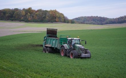
If you farm on clay soil and there are dry conditions, avoid spreading manure. When clay soil dries, it often creates large cracks. If manure is applied on these cracks, it has the potential to flow directly to tile drains, bedrock, or groundwater. This issue is perpetuated even more in areas with shallow soils where manure only has a few feet to travel to hit bedrock. In addition to contaminating groundwater, the nutrients in the manure are not held by the soil and lost below the root zone.
If spreading cannot be avoided in dry clay soil conditions, use tillage to disrupt the cracks. When spreading, apply in smaller volumes and monitor field drainage tiles for several days afterwards. Have spill containment and respond material ready in case manure is found in the tile drain.
Key Takeaways
Karst topography and Silurian bedrock are areas that are more susceptible to water contamination due to shallow soils and increased number direct conduits to groundwater, such as sinkholes. When farming in these areas, and especially spreading manure, it is important to follow all rules and regulations. Being aware and choosing better management practices for the most sensitive spots on your farm can aid in reducing nutrient losses and can help positively impact water quality. Follow a nutrient management plan, utilize soil conservation practices, and comply with NR 151 standards to lessen the impact these sensitive areas can have on water quality.
View Part 1 of this article series: Wisconsin’s Unique Landscapes: Karst Formation and Silurian Bedrock Explained
More resources
https://dnr.wisconsin.gov/sites/default/files/topic/Nonpoint/590summary2015NPM.pdf
https://www.kewauneeco.org/i/f/files/Land%20%26%20Water%20Conservation/NR151%20Cheat%20Sheet.pdf
https://www.usgs.gov/mission-areas/water-resources/science/karst-aquifers
https://www.co.door.wi.gov/DocumentCenter/View/564/Protect-the-Water-You-Drink-PDF
https://widnr.widen.net/s/rlhnjrdsgr/karstremindersrecognizingfeaturespreventingproblems
https://fyi.extension.wisc.edu/fdlag/files/2019/08/NR151FondDuLacFactSheet.pdf
https://www3.uwsp.edu/cnr-ap/watershed/Documents/Masarik/swcs_masarik.pdf

 Wisconsin’s Unique Landscapes: Karst Formation and Silurian Bedrock Explained
 BMPs of NMPs #6: On-Farm Implementation of Nutrient Management in Southwest WI


