Grazing to Protect Surface Water: Considering critical and sensitive areas
What are critical and sensitive areas?
How to identify critical and sensitive areas
What are the most vulnerable times of year for soil and nutrient runoff?
How can critical and sensitive areas be managed in a year-round grazing operation?
Many of Wisconsin’s abundant freshwater resources are impaired due to elevated phosphorus (P) and sediment levels (DNR, 2024). In a grazing system, it is important to take into consideration management, weather, and landscape characteristics to minimize impacts to surface water quality (Vadas et al., 2015).
Certain critical and sensitive areas of the farm — such as concentrated surface flow areas — and certain times of year — such as periods of frozen soil — create conditions that leave the landscape particularly vulnerable to nutrient losses. Identifying critical and sensitive areas of your farm and managing them accordingly, especially at sensitive times of year, protects surface water quality while maintaining a productive grazing system.
This article will:
- Define critical & sensitive areas
- Help farmers identify where critical and sensitive areas exist on their farms
- Provide guidance on how to manage them during times of the year when they are most prone to damage, sediment loss, and nutrient transport
What are critical and sensitive areas on farms?
Unique areas or ecosystems across the landscape that play significant environmental and biological roles are referred to as critical areas. These areas require special protection or management due to the impact damage would have on the broader environment. An example of this would be a perennial stream bottom, where livestock access should be limited to short, infrequent durations through managed grazing to protect the stream banks.
Areas or ecosystems that are more susceptible to damage from agricultural practices are referred to as sensitive areas. These areas may not play as significant roles as critical areas, but they still require special protection or management because of heightened vulnerability. An example of this would be the floodplain adjacent to a stream bottom, which should be grazed only during nonsaturated conditions.
How to identify critical and sensitive areas on farms
The point of focusing on critical and sensitive areas is not to avoid grazing them altogether, but rather to devise a management plan that allows the areas to be grazed at the proper time to reduce water quality risk. Identifying these areas on your farm is the first step in managing them responsibly. While many critical and sensitive areas are specific to an operation, these are some of the most common conditions qualifying an area as critical or sensitive:
- Concentrated flow paths
- Drainage tiles and tile inlets
- Drainage class: poorly drained soils
- Hydric soils: high water table
- Frequent flooding
- Ponding
- Intermittent streams
- Perennial streams
- Waterbodies: ponds, lakes
- Extreme slopes
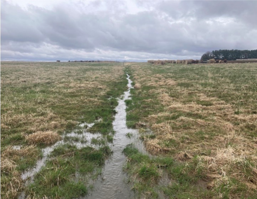
Concentrated flow paths are places on the landscape, both naturally occurring and man-made, where water flows from an area of approximately 5 acres or more and concentrates in a channel formed by topography.
If concentrated flow paths are not properly protected with vegetation, erosion can cause the formation of gullies, exacerbating soil and nutrient loss and making the land extremely difficult to manage. Improper grazing management in concentrated flow paths can lead to overgrazing of vegetated cover and nutrient loading contributing to soil and nutrient losses.
Any livestock grazing within concentrated flow paths should be limited to times when the soil is not saturated, and runoff is not likely. Outwintering of livestock should not occur any closer than 35 feet from the center of the concentrated flow path, and traffic patterns from livestock or equipment should not cross these areas during periods of saturation.
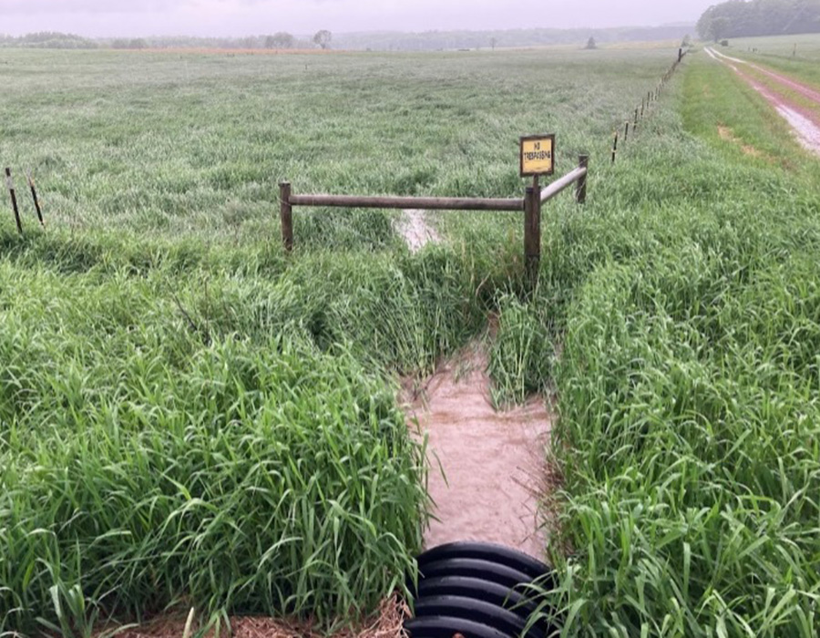
Drainage tiles and tile inlets are installed to drain fields of excess moisture. These have a significant impact on surface water quality because they provide a direct conduit from the field to an off-field outlet. Tile inlets are typically installed in low areas of a field and allow surface water to directly enter tile lines. Subsurface tile lines should be mapped, and a 35-foot buffer should be maintained from the center of lines when outwintering livestock on pasture. A 100-foot buffer should be maintained around tile inlets when soils are frozen or saturated. Grazing over tile lines or near inlets can be done responsibly during summer.
Soil drainage classes range from excessively drained to very poorly drained. There are seven classes. Soils rated as very poorly or poorly drained are sensitive to grazing because water does not readily move through the soil profile resulting in ponding and surface runoff conditions for a large portion of the year. Soils rated as somewhat poorly drained may have seasonal high water tables during fall or spring. These areas should only be grazed when conditions are dry and should only be used for outwintering when soils are frozen.
Hydric soils are those that are saturated with water for long periods of time creating low oxygen conditions and organic matter accumulation. Indicators of hydric soils include the presence of muck and/or a dark soil surface or portions of the soil that tend to pond and saturate for the majority of the year. Some hydric soils are never suitable for grazing, and those that can be managed responsibly should only be grazed under very dry conditions. These areas are often saved for grazing during late summer when conditions are dryest, providing relief to remaining pastures during the summer slump.
Flooding frequency is a measure of how often low spots are temporarily inundated or filled by overflowing streams or runoff from adjacent. Each soil is rated for its flooding frequency, and any soils that flood occasionally, frequently, or very frequently should be managed with care. Temporary grazing of these areas may occur only under dry conditions when the potential for damage is minimal.
Ponding is standing water in a closed depression. Similar to flooding frequency, soils are rated for ponding frequency, and those rated as occasional or frequent should be avoided when wet. Soil drainage classifications, hydric soil determinations, flooding frequency ratings, and ponding frequency ratings can be found online on the USDA Web Soil Survey.
Intermittent streams flow seasonally, typically during wet portions of the season, but cease to flow under dry conditions. A 35-foot buffer should be maintained adjacent to these areas so livestock can be fenced out when they are flowing. Grazing within them should only occur when conditions are dry.
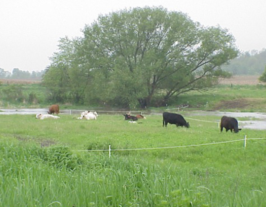
Perennial streams flow continuously year-round. These are considered Surface Water Quality Management Areas (SWQMA) which are regulated through Wisconsin’s 590 Nutrient Management Standard. These areas should be managed as separate units with a 300-foot buffer to keep livestock out during periods when soils are frozen.
Additionally, during times when soils are not frozen, these areas should only be grazed when soils are not saturated. Further, rotational grazing management should be implemented to limit livestock exposure to streambanks to short durations (Figure 4). Outwintering of livestock should not occur within 300 feet of perennial streams.
Waterbodies include ponds and lakes and are also considered SWQMAs. A 1,000-foot buffer should be maintained around these when soils are frozen or saturated. Outwintering should not occur within the 1,000-foot buffer and non-winter rotational grazing should only occur within these areas when soils are not saturated.
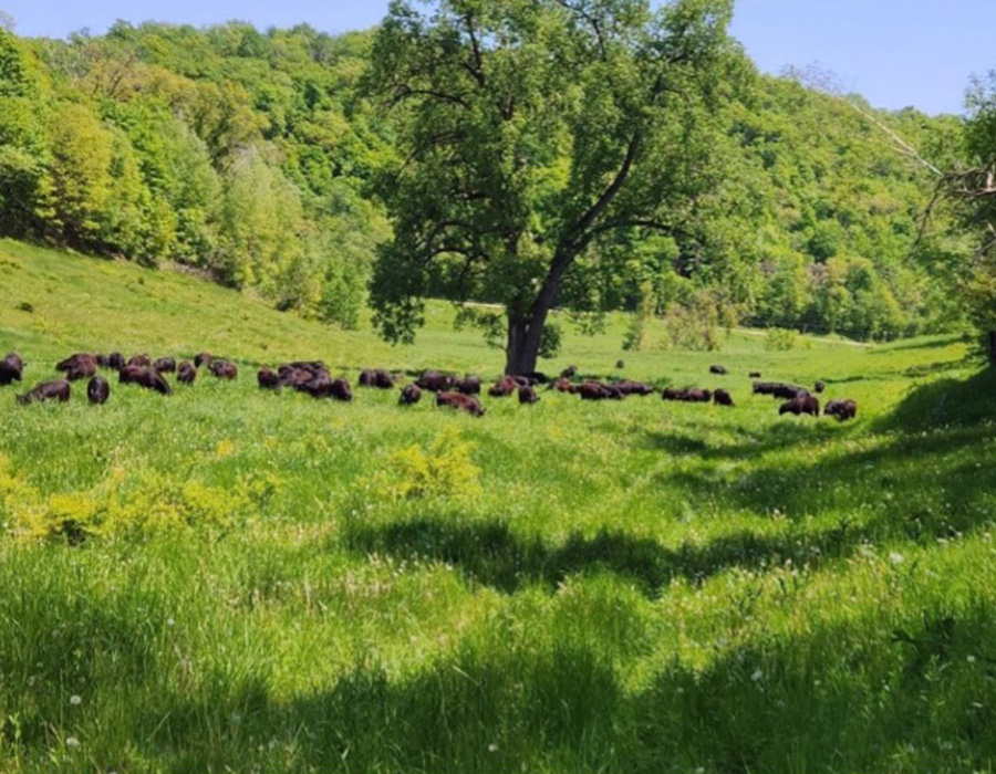
Extreme slopes are especially vulnerable to erosion and surface runoff due to topography. Management of extreme slopes is site-specific. Grazing slopes exceeding 12% (Figure 5) requires attention to grazing management to ensure adequate residual cover is maintained. Outwintering of these sites can be done responsibly with appropriate planning.
Summary of and resources for identifying critical and sensitive areas
Any area of a farm containing the conditions above are considered a critical and sensitive area. These areas can be grazed productively when managed properly, but they are not a place conducive to building livestock housing structures, lanes, or watering facilities. Most of these conditions are visible on the landscape at certain times of year. Many of them are obvious to a farmer who’s been managing the land for several seasons. But there are other resources that can help with identifying critical and sensitive areas so that observations on the landscape may be confirmed.
Web Soil Survey
With this tool you can identify soil types, soil drainage classes, hydric soils, flooding frequency, and ponding.
SnapPlus
This nutrient management software can be used to develop a farm nutrient management plan, in addition to estimating soil and nutrient loss under certain practices, and its accompanying mapping software can indicate intermittent streams, perennial streams, personal wells, and SWQMAs, among other things.
County mapping websites
Used to identify topography, elevation, slope and other important features.
What are the most vulnerable times of year for soil and nutrient runoff?
Throughout the year, there are seasonal and weather conditions that can make critical and sensitive areas more vulnerable to soil and nutrient losses through surface runoff.
Research from Wisconsin Discovery Farms indicates that March is a key month for surface runoff at dairy and beef cattle grazing sites (Figure 6A). During this late winter period, there is generally a lot of water arriving at the soil surface from melting snowpack and spring rains. However, soils are often frozen or saturated at this time, restricting infiltration and making runoff likely. Runoff will converge in concentrated flow paths and may prompt flow in intermittent streams.
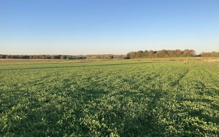
Surface runoff is less common during the growing season due to higher soil infiltration capacity as well as plant water demand and evapotranspiration. However, runoff can occur from grazed areas during the summer months given sufficient soil moisture and rainfall.
For example, Discovery Farms monitoring stations recorded several large runoff events from grazed sites in June and July (Figure 6B). These events were the result of large summer storms with heavy rainfall arriving to soils that were already wet from smaller rain events in the days prior. These data illustrate that runoff from grazed areas can vary from year to year based on weather and soil conditions. As such, it is important to continually assess critical and sensitive areas throughout the year for water movement and nutrient loss vulnerability.
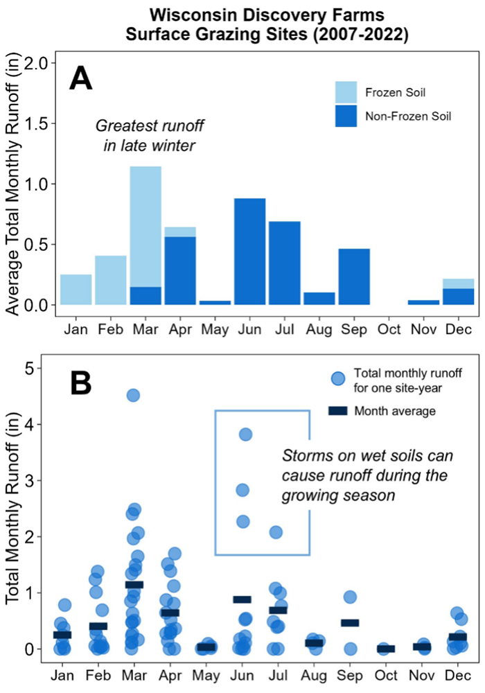
Figure 6B. Distribution of all monthly total runoff values across 22 site-years of data from Discovery Farms grazing sites.
Summary of and resources for identifying when soil and nutrient runoff is most likely
While the conditions that characterize the most vulnerable times of the year are somewhat predictable, there is quite a bit of variation from year to year and conditions must be monitored on an annual basis. Current conditions can be monitored with the following tools:
Runoff Risk Advisory Forecast
Likelihood for manure runoff based on soil frost, soil moisture, and weather forecasts.
Wisconet
Weather station network across Wisconsin containing precipitation, soil temperature and moisture data.
How can critical and sensitive areas be managed in a year-round grazing operation?
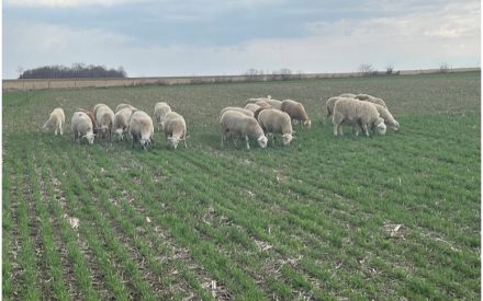
Most of the areas identified in this article as critical and sensitive can be used productively with careful planning, using the following guidelines.
Consider fencing off critical and sensitive areas such as concentrated flow paths, intermittent streams, or those prone to flooding to manage as independent units. This allows you to avoid grazing these areas during vulnerable times of year.
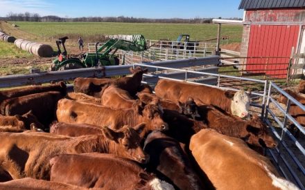
Choose overwintering locations, exercise lots, and other high-use areas with caution. Avoid critical and sensitive areas like those with poorly drained or hydric soils.
Consider soil testing and choosing areas lower in nutrients for overwintering and heavy-use areas. This reduces the risk of building up nutrient levels beyond the crop need. Nutrients, such as phosphorus, in excess of crop need can then be lost with runoff and erosion. Rotating outwintered and heavy-use areas from year to year reduces the chance of excess nutrient build-up and has the potential to boost yields in areas that are most nutrient deficient.
Certain portions of the farm and certain times of year can account for a majority of soil and nutrient losses on a farm. A grazing management plan that addresses the responsible management of critical and sensitive areas during the most vulnerable times of year greatly reduces the risk of negative water quality outcomes without sacrificing a productive grazing system.
Resources
References
Vadas, P. A., Busch, D. L., Powell, J. M., & Brink, G. E. (2015).
Monitoring runoff from cattle-grazed pastures for a phosphorus loss quantification tool. Agriculture, Ecosystems, and Environment, 199, 124-131. DNR. (2024).
Water Condition Lists: 2024 Condition Lists. https://dnr.wisconsin.gov/topic/ SurfaceWater/ConditionLists.html Authors Jason Cavadini, Grazing Outreach Specialist, UW-Madison Division of Extension Kelsey Hyland, Agriculture Water Quality Outreach Specialist, UW-Madison Division of Extension Laura Paine, Grazing Outreach Coordinator, UW-Madison Division of Extension Contributors Adam Abel, Grazing Specialist, USDA-Natural Resources Conservation Service Ellen Albright, Researcher, Discovery Farms Wisconsin
Contributors:
Adam Abel, Grazing Specialist, USDA-Natural Resources Conservation Service
Ellen Albright, Researcher, Discovery Farms Wisconsin